| |

|
Select Photo Number:
|
- Click on the small photo below to open the large photo in your browser, enabling the photo to be
downloaded using the Browser "Save Image As..." option.
- Aerial photo navigation tips are at the bottom of this page.
|
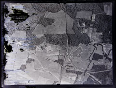
Aerial Photo 01-01
|

|
|
- The "1" series of the Aerial Photos starts at the Northern end of the displaced communities, goes from right to left
with increasing numbers going South.
- To view the aerial photos so that North is at the top of the photo, the photo number needs to be at the bottom right of the page.
- Aerial photos were taken from an airplane, so they will not line up with topographical maps and will not be to any scale of topo maps.
- There will sometimes be landmarks that are the same in both the aerial photos, old maps and new maps such as power lines, cemeteries, railroads tracks,,
parts of roads, and sometimes creeks & rivers. However, keep in mind that creek and rivers were sometimes relocated from the Robertsville time
until now. Part of Poplar Creek used to run into the farm pond that later became the Oak Ridge swimming pool, but this was relocated when the
Secret City developed.
- Aerial photos provided by: Dennis Eggert and Byron Hartzler.
- Army Corp. of Engineer photos originally obtained years ago by: Don Raby and Bob Copeland.
- Aerial photo navigation tips by: Tom Smith.
- Aerial photos original source: Army Corp. of Engineers, "Kingston Demolition Range" Collection, National Archives in Atlanta, Georgia.
|
|
|
|
|